
Cnoc an Mhama [Knocknagussy]
Good walks are even better shared.
Overview
Cnoc an Mhama [Knocknagussy]
Introduction
Cnoc an Mhama, situated in the heart of the Sperrin Mountains, stands proudly at 702 meters. Often overshadowed by its taller neighbours, this Marilyn offers a unique walking experience away from the hustle and bustle, making it a hidden gem for those in the know.
Geology
The geology of this area will tickle the fancy of amateur geologists and curious hikers alike. Dominated by layered sedimentary rocks, the landscape tells a tale of geological processes that have shaped its impressive contours. Watch your step, and you might just discover a few interesting stones along the way.
Routes
Glenshane Pass Start Point
This route is the most commonly taken and is perfect for moderate walkers. Packing your hiking boots rather than flip-flops is advisable here. The distance is about 5.5 km with some delightful scenery along the way, and the ascent shouldn't take more than 2.5 hours.
Summit Features
At the summit, you'll be greeted by a charming stone cairn. It’s not quite the Eiffel Tower but stands as a quiet testament to all who’ve made the trek.
Terrain Type
With grassy slopes and occasional rocky outcrops, the terrain here provides a bit of variety without getting too bogged down. There are moments that may require a little scramble, but nothing that would require a mountaineer's rope.
Views
On a sunny day, the views from the top will make you want to shout into the abyss—don’t worry, it welcomes the sound of your joy. You'll see the beautiful Sperrin Mountains stretching out before you, with a keen eye possibly spotting the Mourne Mountains off in the distance. Spring and autumn are particularly splendid, with views complemented by vibrant colours.
Hazards
Be mindful of the weather; it can change faster than a politician's promise. Fog may sneak in unexpectedly, reducing visibility. Slippery paths can challenge even the most experienced walkers, so appropriate footwear is a must.
Nearby Summits
If you're feeling ambitious, consider bagging nearby peaks such as Mount Poulter or Glenelly Head. They offer similar trails and stunning views, adding a dash of adventure to your trip.
Access
Nearest Parking: The Glenshane Pass has ample parking, although it does fill up quickly on weekends.
Public Transport: While public transport is hardly abundant in these parts, a bus will take you to Dungiven, about 12 km from the start point.
Nearest Town: Dungiven has amenities such as cafes and shops to cater to your pre- or post-hike hunger.
Facilities
Facilities are a bit scant near the mountain, but Dungiven will have you covered with eateries and local conveniences.
History
The name Cnoc an Mhama carries cultural significance with deep roots in Irish folklore. It’s said that many a tale was woven amongst the hills here, making it a cultural tapestry worth exploring.
Conclusion
Whether you're a seasoned hiker or a casual walker, Cnoc an Mhama offers a delightful experience wrapped in natural beauty and cultural charm. Just remember to pack water and perhaps a light snack – you’ve earned it!
Explore routes near Cnoc an Mhama [Knocknagussy]
Public walks starting within 80 km of this hill. Nearby does not mean a route reaches the summit; check its map and access before setting out.
No public routes are currently listed within 80 km of Cnoc an Mhama [Knocknagussy] on Walkmates. This does not mean there are no paths here. Explore the map and check local access information before planning a walk.
Route planning notes
These notes describe possible approaches, not verified navigable routes or permission to cross land. Check current paths, local access rules and conditions before setting out.
Glenshane Pass Start Point
This route begins at the Glenshane Pass, providing a straightforward ascent along well-trodden paths. Expect some mild scrambling towards the summit.
Make a day of it, together
Find someone to share the walk with, or organise a day out along a route you like.
Hill facts and local notes
Classifications
Elevation
454m
1,490 ft
Prominence
100m
Coordinates
53.5208, -9.5416
L978534
OS Map
38
At the Summit
The summit is marked by a small stone cairn, offering a sense of accomplishment to hikers as they stand atop this beautiful peak.
Terrain & Geology
Cnoc an Mhama primarily consists of layered sedimentary rocks, which have been uplifted and eroded over the ages, creating stunning cliffs and slopes. The area is rich in natural features, including unique rock formations and abundant vegetation.
Views & Scenery
From the summit, you’ll be treated to panoramic views of the surrounding Sperrin Mountains, and on a clear day, you can see as far as the Mourne Mountains and even the distant Lough Neagh.
History & Heritage
Name Origin
Cnoc an Mhama translates to 'Hill of the Breath,' a nod to its location in the stunning landscape and perhaps the fresh air you’ll find at the summit.
Historical Significance
The area has historical significance, as it is steeped in ancient Irish folklore and tales of the Celts.
Getting There & Facilities
Check current local access restrictions, parking rules and transport timetables before travelling. These notes do not confirm public access to the summit.
Parking
There is a dedicated parking area at Glenshane Pass, suitable for several vehicles. It can get busy on weekends.
Public Transport
Limited public transport options are available. The nearest bus service stops in Dungiven, approximately 12 km away.
Nearby Facilities
Facilities are sparse near the mountain; however, Dungiven offers cafes, pubs, and local shops for basic needs.
Safety Information
Known Hazards
- Watch out for rapidly changing weather, especially in higher altitudes. Fog can roll in unexpectedly, and the terrain may be slippery when wet.
General Safety Tips
- Check weather conditions before setting out
- Carry appropriate clothing and equipment
- Let someone know your planned route
- Take a map, compass, and GPS device
- Carry emergency supplies: food, water, first aid kit, torch
Hills
Some common questions about the hills answered
Are there group walks up Cnoc an Mhama [Knocknagussy]?
Many walkers use Walkmates to join or organise walks with others. You can check for group walks around Cnoc an Mhama [Knocknagussy] through the maps
Are there other walkers around Cnoc an Mhama [Knocknagussy]?
Activity varies by location and time, but Walkmates lets you see whether others have shared walks or shown interest in this area. Find other people through the walking friends search walking friends for Cnoc an Mhama [Knocknagussy] search or of course create your own walk for Cnoc an Mhama [Knocknagussy]
Can I organise a walk to Cnoc an Mhama [Knocknagussy]?
Yes. If there aren’t any walks listed already, you can create a walk and make it available for others to join.
If you're signed up to Walkmates, you can create a walk to Cnoc an Mhama [Knocknagussy].
How do I find a walk up this hill?
There are often multiple ways to walk this hill, depending on experience and route preference. Walkmates helps you explore walks and routes that others have shared.
Can I suggest a new route up Cnoc an Mhama [Knocknagussy]?
Yes. You can suggest or create routes to share with others. Walkmates focuses on the social side of walking, so routes are used to help people organise walks and explore areas together, rather than as detailed navigation tools or route libraries.
Other uses really appreciate knowledgeable walkers sharing their routes. Share your favourite route to Cnoc an Mhama [Knocknagussy] here
The is an error or something incorrect about this hill. How do I let you know?
We always strive to keep the information on Walkmates as accurate as possible. If you find an error, please let us know through the contact form and we'll aim to correct it as quickly as possible
Community Discussion
Comments
Location
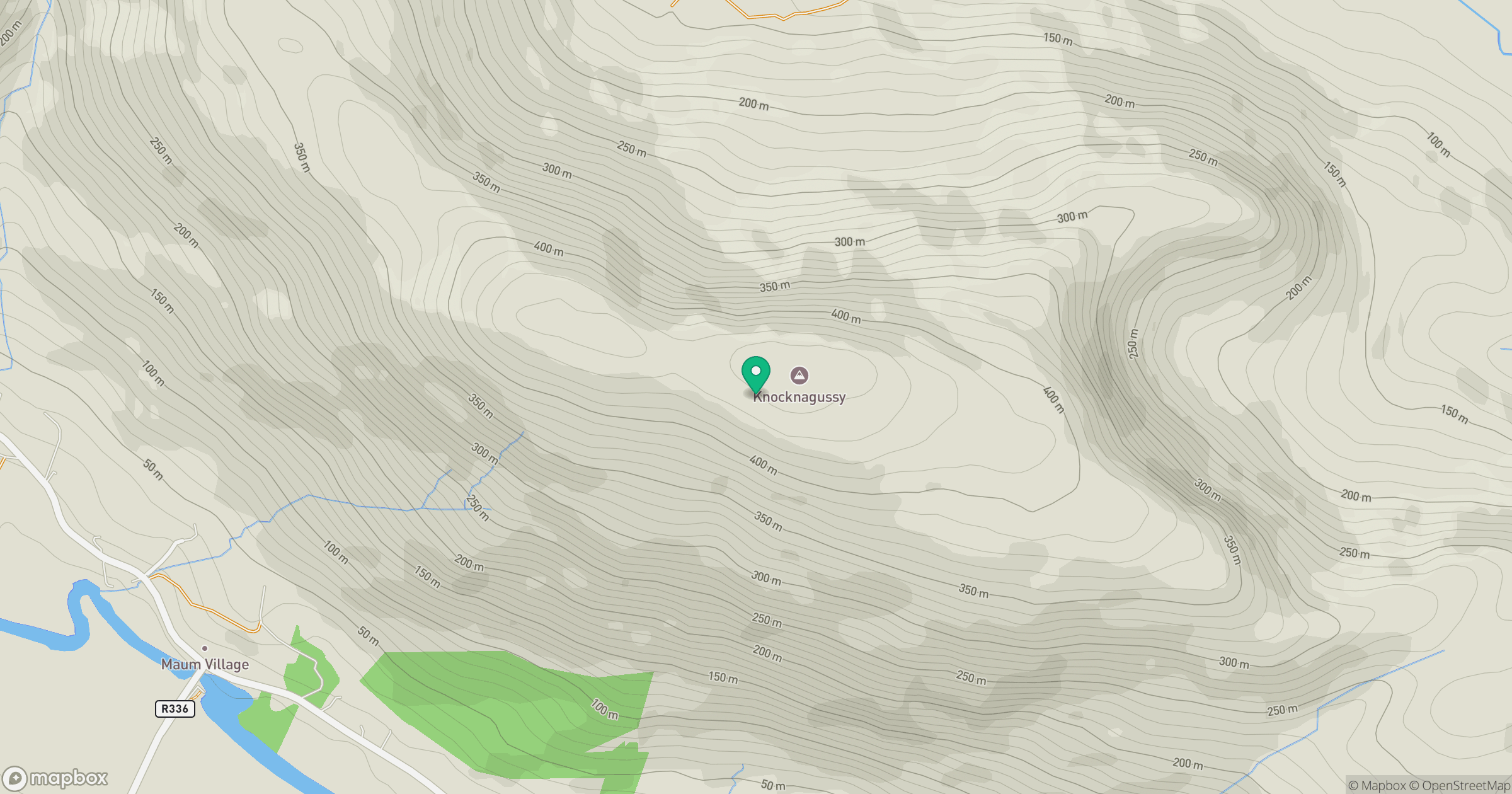
Grid reference: L978534
View on OpenStreetMapOpens a map in a new tab, centred on the hill.
Hills within 30 km
Straight-line distance, not a walking route or confirmation of access.
Croagh Patrick
764m
Mweelrea
814m
Lackavrea
396m
Corcog [Corcogemore]
610m
An Binn Bheag [Ben Beg]
560m
No comments yet. Be the first.